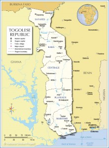
Geography
Togo is on the south coast of West Africa bordering on Ghana to the west, Burkina Faso to the north, and Benin to the east. The Gulf of Guinea coastline, only 51 km, is low and sandy. The only port is at Lomé. The Togo hills traverse the central section.
Capital (and largest city): Lomé  6°7?N 1°13?E
Official language(s): French
Vernacular languages: Gbe languages such as Ewe, Mina and Aja;Kabiyé; and others.
Ethnic groups: African 99% (37 tribes; largest and most important are Ewe, Mina, and Kabre) European and Syrian-Lebanese less than 1%
Government: Republic
- President: Faure Gnassingbé
- Prime Minister: Gilbert Houngbo
Independence: from France | April 27, 1960
Area
- Total: 56,785 km2 (125th) 21,925 sq mi
- Water (%): 4.2
Population
GDP (PPP) 2009 estimate
GDP (nominal) 2009 estimate
HDI (2010): ![]() 0.428 (low) (139th)
0.428 (low) (139th)
Currency: CFA franc


